
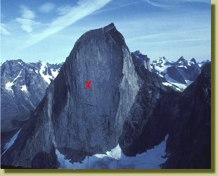
Ketilfjeld, 2010 m seen from a helicopter.
The cross marks our high point
More pictures in the galleri under Tasermiut,
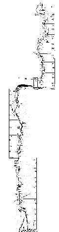
Via Catalan-topo drawn by Magnus Nilsson.
Click for larger version.
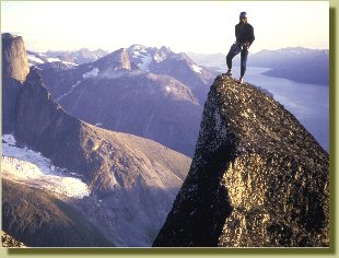
Magnus Nilsson on Pyramiden,
which we climbed by the Swiss Route after the failure on Ketil. Ulamertorsuaq
and Tasermiut Fjord in the background
Ketil
Fjeld, South Greenland, 1987
Article written and
translated 1994
Danish version
Big Walls in Southern Greenland
Deep in among the fjords in southern Greenland lies a small, nearly unknown mountainous area with solid granite, four-thousand-foot big walls, and an inexhaustible wealth of unclimbed lines.
Lying above the Arctic Circle and totally dominated by the largest ice cap outside of Antarctica, the name Greenland might seem slightly misplaced. The fact is that it's a more than onethousand-year-old public relations slogan. In the Greenlanders' Saga, an Icelandic script written in the 1200's, it is recounted why Erik the Red, the father of Leif the Lucky (Leif Eriksson), discoverer of America, in 982 left Iceland with a group of men in order to search for new land. They came to Greenland where the inland ice reaches right down to the sea, sailed south of Cape Farewell, and found fertile grasslands along the bottoms of southwest Greenland's fjords. Eric (with the mind of a modern marketer) called the land he discovered Greenland because he felt a pretty name would be enough to attract people there.
Greenland is a land of mountains, and along almost the entire 39.000 kilometer coastline, glaciers have cut fresh slices through the bedrock and left behind countless numbers of walls and summits, which often tower several thousand meters from the surface of the fjords. What Greenland's mountains lack in absolute height they therefore make up for in relative height and also in beauty.
Most of the mountains are of an alpine character and areas such as Qioqe-peninsula and Evighedsfjorden in western Greenland, the Cape Farewell region in southern Greenland, and Stauning's Alps in Schweizer-Land in eastern Greenland had their "golden age" of mountaineering from 1950-1970.
Tasermiut
But if you are looking for clean rock climbing on solid granite, there's only one place to go: Tasermiut (Ketil's Fjord) in southern Greenland, the fjord where Ketil, one of Eric the Red's men, settled.
I remember clearly my shock when, as a young climber, I saw a picture of Tasermiut for the first time. In a book about the Greenland Vikings, there was a picture from an archaeological dig at the ruins of a monastery. In the background, Ketil (2010 m) raised its snow-powdered granite crest like a crooked whale's back high over a chalk white mist. Black meltwater stripes ran in straight unbroken lines down over the western wall and indicated that ledges quite probably simply didn't exist, all the way from the wall's foot to the top, 1200 meters above.
A danish atempt
Many years later, in july 1987, and in as good condition as one can be when one's homeland's highest point is a heap of earth a few meters above sea level, I stood together with my fellow Danes Søren and Uffe, and Magnus from Sweden, at the foot of Ketil (also named Uiluit Qaqa, which is Eskimo for "Oyster
Mountain" most probably named after the rich mussel banks exposed i
fjord at low tide).
We had come here by plane from Copenhagen to Narsarsuaq, one of the two international airports in Greenland. From there, by scheduled helicopter service, we flew to the little fishing village of Nanortalik, and further the last 60 kilometers up the fjord in an open speedboat operated by a local fisherman.
Tasermiut's shores have the obvious advantage of being the most easily accessible mountain area in Greenland, which can, in clement circumstances, be reached in one day from Europe, with a minimum of bureaucracy. This and other parts of western and southern Greenland are open to unrestricted hiking and climbing. In contrast, eastern and northern Greenland necessitate a permit from the Greenland territorial government, plus an insurance policy for emergency search and rescue (coverage: DKR 1,000,000 /US$ 150.000).
On the way up to the foot of the west wall of Ketil, we had to agree that Eric the Red was right: the land is green! Southern Greenland's flora are not at all like the ordinary Arctic variety. With tightly-woven thickets of birch trunks stout as thighs, piles of loose overturned boulders, and billions of mosquitoes, Borneo's jungle seemed like a bed of parsley.
When we reviewed the Danish Mountain Club's Greenland archive, we had learned that there were four routes that went up Ketil's west wall: a couple of French routes, a Spanish route, and a direct route created by the Swiss granite virtuoso Michel Piola. Our attempt to establish a "Danish-Swedish Route" ended at a large loose flake about 200 meters
up. (This line was sussesfully climbed in 2000 by David Jonglez
(France) et Eduardo Alonso (Spain), and called "Anissa").
Via Catalan / Ketil
So instead we turned to making a second ascent of the Catalan route, which follows a salient dihedral system the entire way.It
was climbed in 1984 by E. Ortega, X. Martin, X. Nicolau & J. Verdaguer
at VIb A3.
The first half went fine for us, with crack-climbing between 5.8 and 5.10/A2 and portaledge stops after 450 and 600 meters - the last under a gigantic vaulted overhang which splits the wall a third of the way up. A 60-meter traverse toward the left under the roof ended with a short artificial passage where the overhang was least, and we suddenly found ourselves in new terrain: gigantic vaulted slabs and few traces of the "clean line" we had observed from below. At 11.00 pm on the third day we started to run into problems. Magnus, a full rope-length above us, called down that he was able to find neither the way nor a belay stance. He needed more rope! While Søren worked the knot between the two ropes up through the 'biners, Uffe and I hung a bit forlornly and considered the approaching darkness, wind, and rain. Eighty meters above us, Magnus found a belay he could rappel from, and by then the weather had shifted into a full föhn-storm from the inland ice, so we tucked our tails between our legs and rappelled the 23 rope-lengths back down to the glacier.
The weather in southern Greenland never stabilized that summer, and our only success was a repetition of a fine 11-length Swiss route on the southwest wall of The Pyramid, the mountain immediately south of Ketil.
Geography
The mountainous area in South Greenland which is most interesting for climbers lies around the southernmost tip of the inland ice - the Greenland ice cap - from Tasermiut south toward Cape Farewell, and north up along the east coast to the extremely difficultly accessible Apostle's Thumb (2300 m.) in Lindenow's Fjord.
Geologically, the area was formed during an 1.8 billion year old mountain-folding process, which culminated in the intrusion of the Ketil granite - coarsely-grained and quartz-poor - which as a rule is solid but can also be crumbly. The granite dominates the innermost 20 kilometers of Tasermiut's eastern flank, with Ketil and Ulamertorssuaq (Eskimo for "The Large Cylinder") as the most spectacular formations, as well as the remarkable mountain Kirkespiret ("The Church Spire" in Danish, also called Napassorssuaq in Eskimo) on Tasermiut's western shore. The Apostle's Thumb is also built of Ketil granite. The rest of the area is covered by more loose rock, talus, and alpine snow terrain, with heights of up to about 2400 m.
A no-guidebook area
The mountain-climbing history of southern Greenland is only about 40 years old, and unfolds from tentative early recon in the accessible mountains, to larger expeditions which deliberately and systematically went after all the peaks in a concentrated area, and finally to more recent big wall projects on the more demanding cliffs, which have never been a scarce resource in the area. There are no guide books for the climbed routes. These are at most registered as simple sketches on photos in the Danish Mountain Club's Greenland archive, in - among other sources - High Mountain Info on the web:
http://www.planetfear.com/climbing/highmountainmag/mountaininfo
or at Nanortalik Tourism.
Many routes are simply not documented, and certain climbers have expressed the opinion that Tasermiut should be preserved as a recordless adventure area where climbers can set up their own routes without knowing that they might be following in the footsteps of others.
The three dominant nationalities in the development of this area have been French, British, and Irish. The French have been particularly active: they carried out the first expedition in 1956 and their activity reached a high point (no pun!) in 1975, when three separate expeditions with altogether 80 participants among other things put up the first route on Ketil's west wall. In 1987, in contrast, we didn't meet a single person in 4 weeks.
On Ketil's west wall are the four routes mentioned above - all approximately 1400 meters long and graded according to the French system at ED 6a to 6b and A2 to A3. The easiest route to the top of Ketil was climbed on the south wall by Austrians in 1974. This route was rated VI (UIAA). The north and east walls are as yet unclimbed because of heavy lichen growth and threatening snow fields. Ketil's two satellite peaks, the Pyramid and Pingasut (Eskimo for "Three"), each have a couple of routes - among them the aforementioned Swiss Route on the former's southwest wall (11 rope-lengths, UIAA grades VIto VI+).
In the Ulamertorssuaq Valley, south of Ketil, you find yourself surrounded on all sides by walls of 300 to 1000 meters. The most remarkable is "The Great Cylinder" - Ulamertorssuaq (also known as Suikkaasuaq - "The Very Solid"), which in 1984 had two routes: the French Route (approximately 800 m., rated VI/A2, French grading), and the Swiss Route
(put up by Michel Piola et al., - approximately 900 m., Vlb/A3, French grading). Later on several has been added, i.e. the German "Moby Dick" at UIAA 9+ and Danish "Piteraq".
East of the end of the Ulamertorssuaq Valley there is a white 300 meter-high granite wall, now sporting several routes. The wall is often referred as Naluumasortoq together with the peak behind (2051 m) which raises itself 800 meters over a little but violently creased glacier. A left-facing dihedral - one of the most obvious lines in the area - goes almost all the way to the top .
Perhaps it's been climbed, perhaps not.
On the other side of Tasermiut is the deeply clefted Kirkespiret (1590 m) with two Austrian routes on the east and west sides. The north wall goes 300 meters straight up with fine unbroken and unclimbed crack lines. The area on the west side of the fjord has also been the site of intensive gold exploration since 1993, when geologists found a kilometer-long quartz vein at the foot of Kirkespiret containing visible gold!
Climbing possibilities outside of the Tasermiut fjord are similarly inexhaustible. In the Ilua fjord system to the southeast, there are finely-shaped peaks with cliffs almost as solid as those in Tasermiut - among other places on the island of Pamiagdluk.
On the island of Sermersoq, north of Nanortalik, an Irish expedition, led by the tireless Joss Lynam, undertook in 1993 a whole batch of first ascents. And real expedition enthusiasts can charter a helicopter (paying for a search and rescue insurance policy) and visit the Apostle's Thumb in Lindenow's Fjord on the east coast. Be prepared for colder weather and loose cliffs. Southern
Greenland is at least, for Europeans, an easily-accessible goal for a climbing expedition, with rich possibilities for setting up completely new routes. Add to this a diverse natural experience, with bountiful flowery meadows, iceberg-filled fjords, and an ever helpful Eskimo population.
Getting there
The only practical way to get to Greenland is by air from Copenhagen, to one of the two airports: Kangerlussuaq (Sondre Stromfjord) in West Greenland and Narsarsuaq in South Greenland.
To Narsarsuaq go three flights a week in high season. An open ticket costs DKK 8500 round-trip (approximately USD 1200), and an special fare ticket, with a validity time of between 14 days and 2 months, costs approx. DKK 5400 (USD 850). From there, one can take routinely scheduled helicopter flights to the island and village of Nanortalik, DKK 2300 (appox. USD 350). To travel from Nanortalik into the fjords and mountains, you should contact the tourist office in Nanortalik. They can service you with their own boat or get you in contact with boat owners. Expect to pay several thousand danish kroner for return trip the 60 km to base camp in Klosterdalen.
Provisions
In all of the towns, there are good supermarkets and stores. In Nanortalik there are two large supermarkets, and most common food supplies can be bought for prices which are basically the same as those in Scandinavia with the exception of more expensive vegetables and fresh fruit. Freeze-dried provisions should be brought from home. The currency is Danish crowns (1 USD = about 7 DKK).
Addresses/Contacts
Travel Bureaus:
Albatros Travel
Kultorvet 11
DK 1175 Copenhagen K
info@albatros-travel.dk
www.albatros-travel.dk
Greenland Travel
Gammel Mønt 12
Box 130
DK-1004 Copenhagen K
Tel: (+45) 33 13 10 11
Fax: (+45) 33 13 85 92
www.greenland-travel.dk
Greenland Maps and Aerial Photos
Nordisk Korthandel / Scanmaps
Copenhagen
www.scanmaps.dk
Map of Tasermiut (Ketil's Fjord):
Danish Geodesic Institute,
"60 V.2 Nanortalik,"
1979, 1: 250.000
Expedition permits for eastern and northern Greenland as well as the inland icecap (not necessary for western and southern Greenland):
The Danish Polar Center
Strandgade 100 H
DK - 1401 Copenhagen K
Tel: (+45) 32 88 01 00
Fax: (+45) 32 88 01 01
www.dpc.dk
Basic Facts
Land area: 2.175.600 sq.km (836,300 square miles) = the world's largest island;
of this area, only 341.700 sq.km (129,846 sq.mi.), or 16%, is ice-free.
The highest mountain is Gunnbjorn Fjeld, 3.733 m.
Population: Approx. 50.000, of whom 40.000 are native Greenlanders.
Languages: Greenlandish (= Eskimo); also Danish in the towns.
Largest town: Nuuk (14.000 inhabitants).
Average summer temperature for Nanortalik (July): 6.5°C (42°F).
Maximum summer temperature recorded: 17.1°C (63°F).
Precipitation: 53 mm (2 inches).
Higher temperatures and less precipitation in the fjords around Ketil Fjeld.
Approximately 50/50 chance of stable weather for the entire summer.
References
Hoff, Erik. Mountaineering in Greenland before 1966. In Berge der Welt, Vol XVI, 1966/67.
Hoff, Erik. Mountaineering in Greenland, 1967 - 1976. American Alpine Journal, 1979, pp. 125 -152.
Rotovnik, Dolfi. Mountaineering in Greenland, 1977 - 1986. American Alpine Journal, 1988, pp. 93 - 106.
More picture in the galleri under Tasermiut,
2003